
Make a donation
Gear up for your next adventure:
As an Amazon Associate, this site earns from qualifying purchases at no extra cost to you.
Nods topographic map
Click on the map to display elevation.
Make a donation
Gear up for your next adventure:
As an Amazon Associate, this site earns from qualifying purchases at no extra cost to you.
Nods
Nods est un village de l'est de la France, situé sur le plateau de Vercel, à 720 mètres d'altitude. On y accède par la RN 57 entre Besançon et Pontarlier.
Make a donation
Gear up for your next adventure:
As an Amazon Associate, this site earns from qualifying purchases at no extra cost to you.
About this map
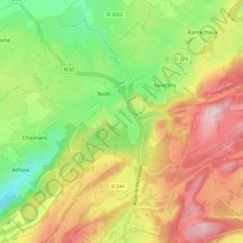
Name: Nods topographic map, elevation, terrain.
Average elevation: 778 m
Minimum elevation: 604 m
Maximum elevation: 973 m
Make a donation
Gear up for your next adventure:
As an Amazon Associate, this site earns from qualifying purchases at no extra cost to you.
Other topographic maps
Click on a map to view its topography, its elevation and its terrain.
Nods
France > Bourgogne-Franche-Comté > Doubs > Les Premiers Sapins
Nods est un village de l'est de la France, situé sur le plateau de Vercel, à 720 mètres d'altitude. On y accède par la RN 57 entre Besançon et Pontarlier.
Average elevation: 741 m