Geolocate

Breitenau topographic map

Click on the map to display elevation.

About this map

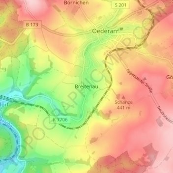
Name: Breitenau topographic map, elevation, terrain.

Location: Breitenau, Oederan, Mittelsachsen, Sachsen, 09569, Deutschland (50.82856 13.14282 50.86856 13.18282)

Average elevation: 400 m

Minimum elevation: 293 m

Maximum elevation: 484 m

Other topographic maps

Click on a map to view its topography, its elevation and its terrain.

09569

Deutschland > Sachsen > Mittelsachsen > Oederan

Average elevation: 424 m

Gear up for your next adventure:

🥾Waterproof Hiking Boots - Essential footwear for rugged terrain and wet Canadian trails
🪑Ultralight Camping Stool - Compact seating for rest stops during long hikes
🚲Handlebar Phone Mount - View topographic-map.com live while cycling
🚲Heavy Duty Bike Lock - Secure your bike at the trailhead or during stops
💡Portable Camping Lamp - Rechargeable lamp for campsite lighting

As an Amazon Associate, this site earns from qualifying purchases at no extra cost to you.