Geolocate

Kovel topographic map

Click on the map to display elevation.

About this map

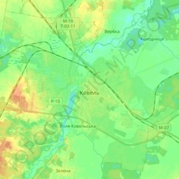
Name: Kovel topographic map, elevation, terrain.

Location: Kovel, Kovel Urban Hromada, Kovel Raion, Volyn Oblast, Ukraine (51.17282 24.63628 51.25415 24.77943)

Average elevation: 173 m

Minimum elevation: 160 m

Maximum elevation: 192 m

Other topographic maps

Click on a map to view its topography, its elevation and its terrain.

Prypiat River

Ukraine > Volyn Oblast

Average elevation: 142 m

Mala Hlusha

Ukraine > Volyn Oblast

Average elevation: 151 m

Prypiat River

Ukraine > Volyn Oblast

Average elevation: 142 m

Pishchane

Ukraine > Volyn Oblast

Average elevation: 166 m

Prypiat River

Ukraine > Volyn Oblast

Average elevation: 142 m

Kulchyn

Ukraine > Volyn Oblast

Average elevation: 183 m

Prypiat River

Ukraine > Volyn Oblast

Average elevation: 142 m

Zavitne

Ukraine > Volyn Oblast

Average elevation: 191 m

Zabolottia

Ukraine > Volyn Oblast > Zabolottia

Average elevation: 158 m

Lutsk

Ukraine > Volyn Oblast > Lutsk

Average elevation: 205 m

Gear up for your next adventure:

🔦LED Headtorch - Bright and durable light for night activities
🔭Compact Binoculars - Lightweight optics for scouting trails and wildlife
🗺️Topographic Maps - Detailed maps to explore trails, mountains, and wilderness areas
🧥Softshell Jacket - Windproof and breathable jacket for hiking
🔦UV Flashlight - Detect minerals or specific insects in the dark

As an Amazon Associate, this site earns from qualifying purchases at no extra cost to you.