Geolocate

Fasi topographic map

Click on the map to display elevation.

About this map

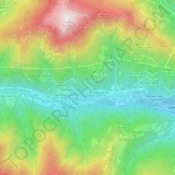
Name: Fasi topographic map, elevation, terrain.

Location: Fasi, Frassino, Cuneo, Piedmont, Italy (44.55353 7.24449 44.59353 7.28449)

Average elevation: 1,130 m

Minimum elevation: 713 m

Maximum elevation: 1,762 m

Gear up for your next adventure:

🧤Rechargeable Heated Gloves - Extreme warmth for Canadian winter expeditions
🧼Travel Hand Sanitizer - Keep hands clean when water is scarce
🔭Outdoor Binoculars - Lightweight binoculars for birdwatching and hiking
🧥Fleece Jacket - Warm and lightweight jacket for layering
🦶Anti-Blister Balm - Prevents friction and hotspots during long ascents

As an Amazon Associate, this site earns from qualifying purchases at no extra cost to you.