Geolocate

Borken topographic map

Click on the map to display elevation.

About this map

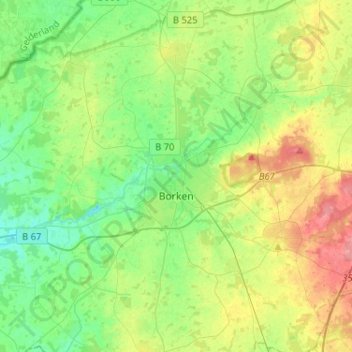
Name: Borken topographic map, elevation, terrain.

Location: Borken, Kreis Borken, North Rhine-Westphalia, 46325, Germany (51.77373 6.73231 51.93287 6.92362)

Average elevation: 56 m

Minimum elevation: 31 m

Maximum elevation: 102 m

Gear up for your next adventure:

Camping Coffee Maker - Brew fresh coffee anywhere on the topographic map
🧤Rechargeable Heated Gloves - Extreme warmth for Canadian winter expeditions
🚲Handlebar Phone Mount - View topographic-map.com live while cycling
🐕Hiking Dog Pack - Let your canine companion carry their own water and food
🧥Waterproof Pants - Keep dry during rainy hiking conditions

As an Amazon Associate, this site earns from qualifying purchases at no extra cost to you.