Geolocate

Barpak topographic map

Click on the map to display elevation.

About this map

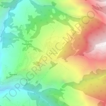
Name: Barpak topographic map, elevation, terrain.

Location: Barpak, Sulikot, Gorkha, Gandaki Province, Nepal (28.18291 84.72451 28.22291 84.76451)

Average elevation: 1,714 m

Minimum elevation: 933 m

Maximum elevation: 2,798 m

Other topographic maps

Click on a map to view its topography, its elevation and its terrain.

Gorkha

Nepal > Gandaki Province > Gorkha

Average elevation: 787 m

Chum Nubri

Nepal > Gandaki Province > Gorkha

Average elevation: 4,445 m

Chum Nubri

Nepal > Gandaki Province > Gorkha

Average elevation: 4,445 m

Gear up for your next adventure:

🥾Trail Hiking Boots - Supportive boots for rough trails
🧥Ultralight Puffy Jacket - Maximum warmth that packs down to the size of an orange
🥾Hiking Boots - Sturdy boots providing ankle support and traction on rugged trails
🧦Outdoor Socks - Durable socks designed for hiking and outdoor sports
🔋Lithium AA Batteries - Long-lasting power that performs in extreme cold

As an Amazon Associate, this site earns from qualifying purchases at no extra cost to you.