Geolocate

Le Case topographic map

Click on the map to display elevation.

About this map

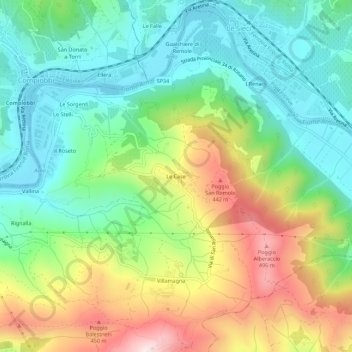
Name: Le Case topographic map, elevation, terrain.

Location: Le Case, Bagno a Ripoli, Florence, Tuscany, 50061, Italy (43.75342 11.36319 43.79342 11.40319)

Average elevation: 231 m

Minimum elevation: 57 m

Maximum elevation: 542 m

Gear up for your next adventure:

🌬️Windproof Camp Stove - Efficient cooking even on exposed mountain peaks
🛏️Camping Sleeping Mat - Comfortable mats for sleeping outdoors
🌡️Emergency Mylar Blankets - Compact thermal protection for unexpected nights outdoors
🥽Outdoor Goggles - Protective eyewear for outdoor activities
🧥Waterproof Hiking Jacket - Protect yourself from rain and wind while hiking

As an Amazon Associate, this site earns from qualifying purchases at no extra cost to you.