Geolocate

Anjur topographic map

Click on the map to display elevation.

About this map

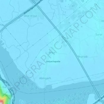
Name: Anjur topographic map, elevation, terrain.

Location: Anjur, Bhiwandi Taluka, Thane, Maharashtra, 400605, India (19.19511 73.01936 19.23511 73.05936)

Average elevation: 5 m

Minimum elevation: -2 m

Maximum elevation: 277 m

Other topographic maps

Click on a map to view its topography, its elevation and its terrain.

Bhiwandi

India > Maharashtra > Bhiwandi Taluka

Average elevation: 15 m

Bhiwandi

India > Maharashtra > Bhiwandi Taluka

Average elevation: 15 m

Gear up for your next adventure:

🥽Outdoor Goggles - Protective eyewear for outdoor activities
🔥Camping Stove - Portable stoves to cook outdoors with ease
🕯️Camping Lantern - Illuminates your entire campsite with high-efficiency LEDs
🌡️Emergency Mylar Blankets - Compact thermal protection for unexpected nights outdoors
🧢Outdoor Visor - Breathable visor for sunny hikes

As an Amazon Associate, this site earns from qualifying purchases at no extra cost to you.