
Make a donation
Gear up for your next adventure:
As an Amazon Associate, this site earns from qualifying purchases at no extra cost to you.
Malpura topographic map
Click on the map to display elevation.
Make a donation
Gear up for your next adventure:
As an Amazon Associate, this site earns from qualifying purchases at no extra cost to you.
Malpura
Malpura is located at 26°17′N 75°23′E / 26.28°N 75.38°E / 26.28; 75.38. It has an average elevation of 132 metres (401 feet). Distance from Jaipur 90 km, Malpura is also Known for Avikanagar – 4 km from Malpura. It is famous for the Central Sheep and Wool Research Institute (CSWRI).
Make a donation
Gear up for your next adventure:
As an Amazon Associate, this site earns from qualifying purchases at no extra cost to you.
About this map
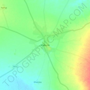
Name: Malpura topographic map, elevation, terrain.
Location: Malpura, Malpura Tehsil, Tonk, Rajasthan, 304502, India (26.24880 75.33298 26.32880 75.41298)
Average elevation: 331 m
Minimum elevation: 312 m
Maximum elevation: 367 m
Make a donation
Gear up for your next adventure:
As an Amazon Associate, this site earns from qualifying purchases at no extra cost to you.