Geolocate

Labangon topographic map

Click on the map to display elevation.

About this map

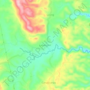
Name: Labangon topographic map, elevation, terrain.

Location: Labangon, Tabogon, Cebu, Central Visayas, Philippines (10.89633 123.97771 10.93633 124.01771)

Average elevation: 132 m

Minimum elevation: 44 m

Maximum elevation: 262 m

Gear up for your next adventure:

🔦LED Flashlight - Powerful and long-lasting flashlight for camping and emergencies
🗺️Topographic Maps - Detailed maps to explore trails, mountains, and wilderness areas
🧭GPS Tracker - Track your location in remote areas safely
🥾Mountain Trail Shoes - High-traction shoes for mountain trails
💡LED Camping Lantern - Illuminate your campsite with long-lasting lanterns

As an Amazon Associate, this site earns from qualifying purchases at no extra cost to you.