
Make a donation
Gear up for your next adventure:
As an Amazon Associate, this site earns from qualifying purchases at no extra cost to you.
Lake Austin topographic map
Click on the map to display elevation.
Make a donation
Gear up for your next adventure:
As an Amazon Associate, this site earns from qualifying purchases at no extra cost to you.
About this map
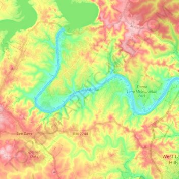
Name: Lake Austin topographic map, elevation, terrain.
Location: Lake Austin, Austin, Travis County, Texas, United States (30.29401 -97.93560 30.39297 -97.77021)
Average elevation: 242 m
Minimum elevation: 148 m
Maximum elevation: 344 m
Make a donation
Gear up for your next adventure:
As an Amazon Associate, this site earns from qualifying purchases at no extra cost to you.
Other topographic maps
Click on a map to view its topography, its elevation and its terrain.
Make a donation
Gear up for your next adventure:
As an Amazon Associate, this site earns from qualifying purchases at no extra cost to you.
Make a donation
Gear up for your next adventure:
As an Amazon Associate, this site earns from qualifying purchases at no extra cost to you.
Barton Creek Greenbelt -- Gus Fruh Access
United States > Texas > Travis County > Austin
Average elevation: 192 m
Mary Moore Searight zMetropolitan Park
United States > Texas > Travis County > Austin
Average elevation: 201 m
Make a donation
Gear up for your next adventure:
As an Amazon Associate, this site earns from qualifying purchases at no extra cost to you.
Walnut Creek Metropolitan Park
United States > Texas > Travis County > Austin
Average elevation: 214 m
Make a donation
Gear up for your next adventure:
As an Amazon Associate, this site earns from qualifying purchases at no extra cost to you.