
Thank you for supporting this site ❤️
Make a donation
Make a donation
Gear up for your next adventure:
As an Amazon Associate, this site earns from qualifying purchases at no extra cost to you.
Rangitoto topographic map
Click on the map to display elevation.
Thank you for supporting this site ❤️
Make a donation
Make a donation
Gear up for your next adventure:
As an Amazon Associate, this site earns from qualifying purchases at no extra cost to you.
About this map
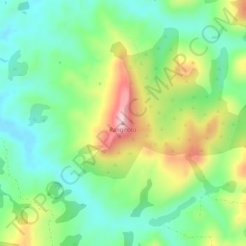
Name: Rangitoto topographic map, elevation, terrain.
Location: Rangitoto, Masterton, Wellington, 5889, New Zealand (-40.94169 176.08831 -40.94159 176.08841)
Average elevation: 117 m
Minimum elevation: 24 m
Maximum elevation: 282 m
Thank you for supporting this site ❤️
Make a donation
Make a donation
Gear up for your next adventure:
As an Amazon Associate, this site earns from qualifying purchases at no extra cost to you.