Geolocate

Huozhou topographic map

Click on the map to display elevation.

Huozhou

The city's altitude ranges from 516 to 2,504.3 m (1,693 to 8,216 ft) in height. The Fen River runs through the city from north to south.

Wikipedia (CC-BY-SA 3.0)

About this map

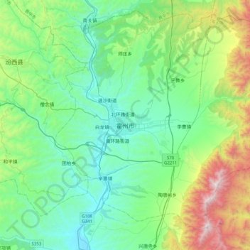
Name: Huozhou topographic map, elevation, terrain.

Location: Huozhou, Beihuanlu Subdistrict, Huozhou City, Linfen, Shanxi, China (36.41194 111.57092 36.73194 111.89092)

Average elevation: 908 m

Minimum elevation: 484 m

Maximum elevation: 2,301 m

Gear up for your next adventure:

🍽️Titanium Camping Spork - Ultralight and indestructible eating utensil
🧤Rechargeable Heated Gloves - Extreme warmth for Canadian winter expeditions
Family Camping Tent - Spacious tent suitable for family camping trips
🏕️Camping Hammock - Integrated protection for sleeping between trees
🧼Travel Hand Sanitizer - Keep hands clean when water is scarce

As an Amazon Associate, this site earns from qualifying purchases at no extra cost to you.