
Barßel topographic map
Interactive map
Click on the map to display elevation.
About this map
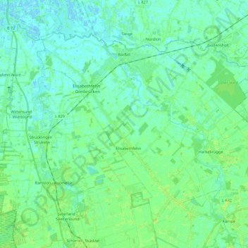
Name: Barßel topographic map, elevation, terrain.
Location: Barßel, Landkreis Cloppenburg, Nedersaksen, 26676, Duitsland (53.08446 7.66701 53.18183 7.88479)
Average elevation: 4 m
Minimum elevation: -2 m
Maximum elevation: 10 m
Other topographic maps
Click on a map to view its topography, its elevation and its terrain.
Addrup
Duitsland > Nedersaksen > Landkreis Cloppenburg > Essen (Oldenburg)
Addrup, Dorfgemeinschaft Addrup, Essen (Oldenburg), Landkreis Cloppenburg, Nedersaksen, Duitsland
Average elevation: 28 m
Neuvrees
Duitsland > Nedersaksen > Landkreis Cloppenburg > Friesoythe
Neuvrees, Friesoythe, Landkreis Cloppenburg, Nedersaksen, 26169, Duitsland
Average elevation: 14 m
Lindern (Oldenburg)
Duitsland > Nedersaksen > Landkreis Cloppenburg > Lindern (Oldenburg)
Lindern (Oldenburg), Landkreis Cloppenburg, Nedersaksen, 49699, Duitsland
Average elevation: 33 m
Cloppenburg
Duitsland > Nedersaksen > Landkreis Cloppenburg
Cloppenburg, Landkreis Cloppenburg, Nedersaksen, 49661, Duitsland
Average elevation: 41 m
Molbergen
Duitsland > Nedersaksen > Landkreis Cloppenburg
Molbergen, Landkreis Cloppenburg, Nedersaksen, 49696, Duitsland
Average elevation: 34 m