Geolocate

Craco topographic map

Click on the map to display elevation.

About this map

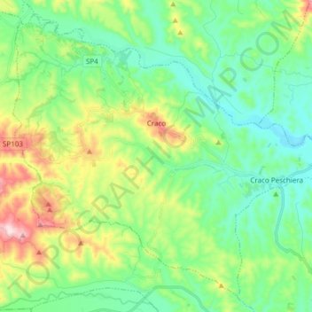
Name: Craco topographic map, elevation, terrain.

Location: Craco, Matera, Basilicata, Italy (40.31589 16.36768 40.41955 16.51869)

Average elevation: 166 m

Minimum elevation: 50 m

Maximum elevation: 451 m

Other topographic maps

Click on a map to view its topography, its elevation and its terrain.

Torricelli

Italy > Basilicata > Matera > Ferrandina

Average elevation: 282 m

Tempa Parese

Italy > Basilicata > Matera > Stigliano

Average elevation: 425 m

Pianelle

Italy > Basilicata > Matera > Montescaglioso > Pianelle

Average elevation: 156 m

Gear up for your next adventure:

🧦Crew Hiking Socks - Comfortable socks for long-distance hikes
🔦LED Headlamp - Hands-free lighting for early morning starts or late finishes
🧦Thermal Socks - Warm socks for winter hiking or camping
💡LED Camping Lantern - Illuminate your campsite with long-lasting lanterns
🧼Biodegradable Camp Soap - Environmentally friendly cleaning for gear and body

As an Amazon Associate, this site earns from qualifying purchases at no extra cost to you.