Geolocate

Burunchel topographic map

Click on the map to display elevation.

About this map

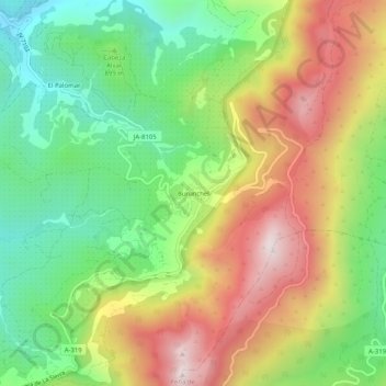
Name: Burunchel topographic map, elevation, terrain.

Location: Burunchel, La Iruela, Jaén, Andalucía, 23479, España (37.92635 -2.97430 37.96635 -2.93430)

Average elevation: 946 m

Minimum elevation: 609 m

Maximum elevation: 1,380 m

Other topographic maps

Click on a map to view its topography, its elevation and its terrain.

Castillo de La Iruela

España > Andalucía > La Iruela

Average elevation: 951 m

Gear up for your next adventure:

🧤Thermal Hiking Gloves - Grip-enhanced gloves for cold-weather altitude trekking
🥾Trail Hiking Shoes - Durable shoes designed for rugged trails
🧦Hiking Socks - Moisture-wicking and comfortable socks for long hikes
💧Reusable Water Bottle - Durable water bottles for hydration on trails
🧥Waterproof Jacket - Lightweight rain jackets for hiking and outdoor activities

As an Amazon Associate, this site earns from qualifying purchases at no extra cost to you.