
Make a donation
Gear up for your next adventure:
As an Amazon Associate, this site earns from qualifying purchases at no extra cost to you.
Esperança Nova topographic map
Click on the map to display elevation.
Make a donation
Gear up for your next adventure:
As an Amazon Associate, this site earns from qualifying purchases at no extra cost to you.
About this map
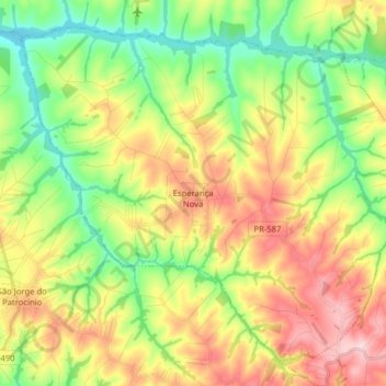
Name: Esperança Nova topographic map, elevation, terrain.
Average elevation: 328 m
Minimum elevation: 234 m
Maximum elevation: 454 m
Make a donation
Gear up for your next adventure:
As an Amazon Associate, this site earns from qualifying purchases at no extra cost to you.
Other topographic maps
Click on a map to view its topography, its elevation and its terrain.
Reserva Biológica das Perobas
Brasil > Paraná > Região Metropolitana de Umuarama > Cianorte
Average elevation: 508 m
Make a donation
Gear up for your next adventure:
As an Amazon Associate, this site earns from qualifying purchases at no extra cost to you.
Caramuru
Brasil > Paraná > Região Metropolitana de Umuarama > São Jorge do Patrocínio
Average elevation: 298 m
Serra dos Dourados
Brasil > Paraná > Região Metropolitana de Umuarama > Umuarama
Average elevation: 426 m
Make a donation
Gear up for your next adventure:
As an Amazon Associate, this site earns from qualifying purchases at no extra cost to you.
Make a donation
Gear up for your next adventure:
As an Amazon Associate, this site earns from qualifying purchases at no extra cost to you.