
Make a donation
Gear up for your next adventure:
As an Amazon Associate, this site earns from qualifying purchases at no extra cost to you.
Gaudernbach topographic map
Click on the map to display elevation.
Make a donation
Gear up for your next adventure:
As an Amazon Associate, this site earns from qualifying purchases at no extra cost to you.
About this map
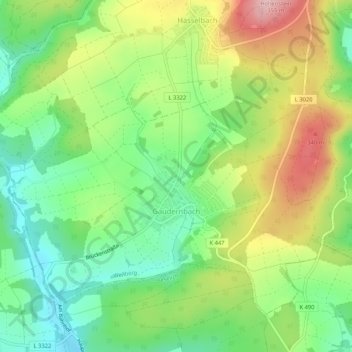
Name: Gaudernbach topographic map, elevation, terrain.
Average elevation: 247 m
Minimum elevation: 168 m
Maximum elevation: 363 m
Make a donation
Gear up for your next adventure:
As an Amazon Associate, this site earns from qualifying purchases at no extra cost to you.
Other topographic maps
Click on a map to view its topography, its elevation and its terrain.
Odersbach
Deutschland > Hessen > Landkreis Limburg-Weilburg > Weilburg > Odersbach
Odersbach liegt auf einer Höhe von 168 m ü. NHN nahe der Kernstadt auf der Westerwaldseite der Lahn. Die Gemarkung der ehemaligen Gemeinde Odersbach grenzt im Norden an Waldhausen, im Osten an Weilburg, im Süden durch eine Fußgängerbrücke über die Lahn an Kirschhofen, im Südwesten an Wirbelau sowie im…
Average elevation: 225 m
Gaudernbach
Deutschland > Hessen > Landkreis Limburg-Weilburg > Weilburg > Gaudernbach
Average elevation: 237 m
Make a donation
Gear up for your next adventure:
As an Amazon Associate, this site earns from qualifying purchases at no extra cost to you.