
Make a donation
Gear up for your next adventure:
As an Amazon Associate, this site earns from qualifying purchases at no extra cost to you.
Hollywood topographic map
Click on the map to display elevation.
Make a donation
Gear up for your next adventure:
As an Amazon Associate, this site earns from qualifying purchases at no extra cost to you.
About this map
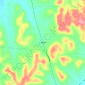
Name: Hollywood topographic map, elevation, terrain.
Average elevation: 270 m
Minimum elevation: 217 m
Maximum elevation: 345 m
Make a donation
Gear up for your next adventure:
As an Amazon Associate, this site earns from qualifying purchases at no extra cost to you.
Other topographic maps
Click on a map to view its topography, its elevation and its terrain.
Columbia
United States > Tennessee > Maury County
According to the United States Census Bureau, the city has a total area of 29.6 square miles (77 km2), of which 29.6 square miles (77 km2) is land and 0.03% is water. Incorporated in 1817, the city is at an elevation of 637 feet (194 m).
Average elevation: 214 m
Make a donation
Gear up for your next adventure:
As an Amazon Associate, this site earns from qualifying purchases at no extra cost to you.