Geolocate

Rodesgrün topographic map

Click on the map to display elevation.

About this map

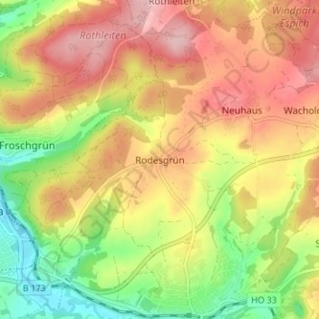
Name: Rodesgrün topographic map, elevation, terrain.

Location: Rodesgrün, Selbitz, Landkreis Hof, Bayern, 95152, Deutschland (50.31610 11.72190 50.35610 11.76190)

Average elevation: 584 m

Minimum elevation: 499 m

Maximum elevation: 657 m

Gear up for your next adventure:

🎒Hiking Daypack - Lightweight and durable backpacks for day trips and excursions
🧦Thermal Socks - Warm socks for winter hiking or camping
🥾Trail Hiking Shoes - Durable shoes designed for rugged trails
🛶Canoe Life Vest - Safety vest for water sports
🥾Light Trekking Boots - Supportive boots for multi-day treks

As an Amazon Associate, this site earns from qualifying purchases at no extra cost to you.