Geolocate

Dobson Landing topographic map

Click on the map to display elevation.

About this map

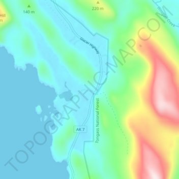
Name: Dobson Landing topographic map, elevation, terrain.

Location: Dobson Landing, Juneau, Alaska, United States (58.47578 -134.79337 58.51578 -134.75337)

Average elevation: 98 m

Minimum elevation: -3 m

Maximum elevation: 426 m

Other topographic maps

Click on a map to view its topography, its elevation and its terrain.

Mendenhall Glacier

United States > Alaska > Juneau

Average elevation: 359 m

Lemon Creek

United States > Alaska > Juneau

Average elevation: 431 m

Lena Beach

United States > Alaska > Juneau > Lena Beach

Average elevation: 103 m

West Juneau

United States > Alaska > Juneau

Average elevation: 110 m

Gear up for your next adventure:

🧳Compression Sacks - Maximize space in your backpack by shrinking gear
🦯Trekking Poles - Reduced impact on joints for steep topographic climbs
💧Hydration Bladder - Hands-free hydration solution for long treks
🥾Lightweight Hiking Boots - Boots for comfort and mobility on long hikes
🧥Insulated Jacket - Keep warm in cold outdoor conditions

As an Amazon Associate, this site earns from qualifying purchases at no extra cost to you.