
Make a donation
Gear up for your next adventure:
As an Amazon Associate, this site earns from qualifying purchases at no extra cost to you.
Mittelsteinach topographic map
Click on the map to display elevation.
Make a donation
Gear up for your next adventure:
As an Amazon Associate, this site earns from qualifying purchases at no extra cost to you.
About this map
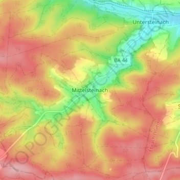
Name: Mittelsteinach topographic map, elevation, terrain.
Average elevation: 377 m
Minimum elevation: 290 m
Maximum elevation: 440 m
Make a donation
Gear up for your next adventure:
As an Amazon Associate, this site earns from qualifying purchases at no extra cost to you.
Other topographic maps
Click on a map to view its topography, its elevation and its terrain.
Walsdorf
Deutschland > Bayern > Landkreis Bamberg
Die Aurach, ein orografisch linker Nebenfluss der Regnitz, fließt, von Feigendorf kommend, durch die fünf Ortsteile in Richtung Stegaurach. Das Gebiet liegt zum größten Teil im Naturraum des Mittelfränkischen Beckens. Zwischen Zettelsdorf und Feigendorf grenzt der Steigerwald im Westen an die Aurach.…
Average elevation: 311 m