Geolocate

Kelona topographic map

Click on the map to display elevation.

About this map

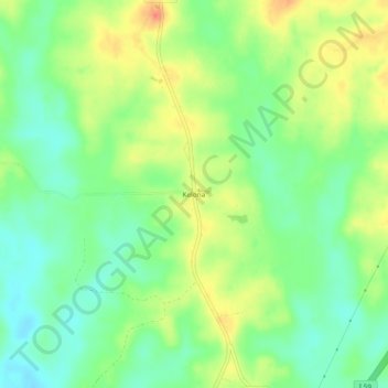
Name: Kelona topographic map, elevation, terrain.

Location: Kelona, Jasper County, Mississippi, United States (31.94210 -89.02894 31.98210 -88.98894)

Average elevation: 126 m

Minimum elevation: 103 m

Maximum elevation: 155 m

Gear up for your next adventure:

🥾Mountain Hiking Shoes - Shoes with superior grip for mountainous terrain
🧴Waterproofing Spray - Restore the DWR coating on jackets and tents
🔋Emergency Crank Radio - Weather alerts and power without needing batteries
🧢Outdoor Visor - Breathable visor for sunny hikes
🧢Beanie Hat - Keep your head warm in cold weather

As an Amazon Associate, this site earns from qualifying purchases at no extra cost to you.