
Thank you for supporting this site ❤️
Make a donation
Make a donation
Gear up for your next adventure:
As an Amazon Associate, this site earns from qualifying purchases at no extra cost to you.
Grenis topographic map
Click on the map to display elevation.
Thank you for supporting this site ❤️
Make a donation
Make a donation
Gear up for your next adventure:
As an Amazon Associate, this site earns from qualifying purchases at no extra cost to you.
About this map
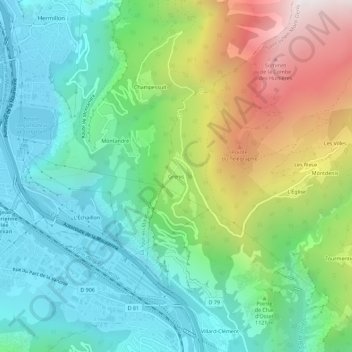
Name: Grenis topographic map, elevation, terrain.
Average elevation: 1,037 m
Minimum elevation: 510 m
Maximum elevation: 2,185 m
Thank you for supporting this site ❤️
Make a donation
Make a donation
Gear up for your next adventure:
As an Amazon Associate, this site earns from qualifying purchases at no extra cost to you.
Other topographic maps
Click on a map to view its topography, its elevation and its terrain.
Canal Trapezoïdal de Saint-Julien Montdenis
France > Auvergne-Rhône-Alpes > Savoie > Saint-Julien-Mont-Denis > Les Plantées
Average elevation: 839 m