Geolocate

Farmerstown topographic map

Click on the map to display elevation.

About this map

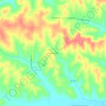
Name: Farmerstown topographic map, elevation, terrain.

Location: Farmerstown, Holmes County, Ohio, 43804, United States (40.46729 -81.74568 40.50729 -81.70568)

Average elevation: 339 m

Minimum elevation: 304 m

Maximum elevation: 378 m

Other topographic maps

Click on a map to view its topography, its elevation and its terrain.

Lake Buckhorn

United States > Ohio > Holmes County > Clark

Average elevation: 300 m

Holmesville

United States > Ohio > Holmes County

Average elevation: 262 m

Nashville

United States > Ohio > Holmes County

Average elevation: 363 m

Gear up for your next adventure:

🔦LED Headlamp - Hands-free lighting for early morning starts or late finishes
🛏️Camping Sleeping Mat - Comfortable mats for sleeping outdoors
🏃Hydration Running Vest - Carry water and maps close to your body for speed
🛌Insulated Sleeping Pad - Critical thermal barrier between you and the cold ground
🧢Beanie Hat - Keep your head warm in cold weather

As an Amazon Associate, this site earns from qualifying purchases at no extra cost to you.