Geolocate

Richmond topographic map

Click on the map to display elevation.

About this map

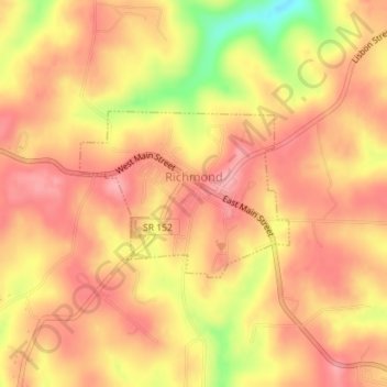
Name: Richmond topographic map, elevation, terrain.

Location: Richmond, Jefferson County, Ohio, 43944, United States (40.42636 -80.78222 40.43796 -80.76300)

Average elevation: 364 m

Minimum elevation: 285 m

Maximum elevation: 400 m

Other topographic maps

Click on a map to view its topography, its elevation and its terrain.

Wolf Run

United States > Ohio > Jefferson County

Average elevation: 359 m

Hammondsville

United States > Ohio > Jefferson County

Average elevation: 293 m

Green Acres

United States > Ohio > Jefferson County

Average elevation: 327 m

La Belle

United States > Ohio > Jefferson County > Steubenville

Average elevation: 267 m

Beechwood

United States > Ohio > Jefferson County > Wintersville

Average elevation: 348 m

Gear up for your next adventure:

🕶️Polarized Sunglasses - Protect your eyes with durable polarized lenses
🧴First Aid Kit - Essential first aid supplies for outdoor emergencies
🎒Hiking Daypack - Lightweight and durable backpacks for day trips and excursions
🎒Hiking Backpack - Lightweight and ergonomic backpacks for day hikes or multi-day treks
🛏️Camping Sleeping Mat - Comfortable mats for sleeping outdoors

As an Amazon Associate, this site earns from qualifying purchases at no extra cost to you.