Geolocate

Fioranello topographic map

Click on the map to display elevation.

About this map

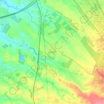
Name: Fioranello topographic map, elevation, terrain.

Location: Fioranello, Municipio Roma VIII, Rome, Roma Capitale, Lazio, 00043, Italy (41.76541 12.54776 41.80541 12.58776)

Average elevation: 105 m

Minimum elevation: 65 m

Maximum elevation: 153 m

Other topographic maps

Click on a map to view its topography, its elevation and its terrain.

Parco del Colle Oppio

Italy > Lazio > Roma Capitale > Rome

Average elevation: 48 m

Giardini del Quirinale

Italy > Lazio > Roma Capitale > Rome

Average elevation: 49 m

Parco della Caffarella

Italy > Lazio > Roma Capitale > Rome

Average elevation: 43 m

Parco Eros Corizza

Italy > Lazio > Roma Capitale > Rome

Average elevation: 36 m

Gear up for your next adventure:

🧦Thermal Socks - Warm socks for winter hiking or camping
🔦LED Flashlight - Powerful and long-lasting flashlight for camping and emergencies
🧰Survival Kit - Essential gear for emergencies in the wilderness
🥾Trail Hiking Socks - Comfortable socks to prevent blisters and fatigue
🧢Sun Hat - Wide-brim hat for sun protection

As an Amazon Associate, this site earns from qualifying purchases at no extra cost to you.