Geolocate

Maunong topographic map

Click on the map to display elevation.

About this map

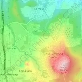
Name: Maunong topographic map, elevation, terrain.

Location: Maunong, Calamba, Laguna, Calabarzon, 4027, Philippines (14.15525 121.14342 14.18496 121.17228)

Average elevation: 141 m

Minimum elevation: 18 m

Maximum elevation: 319 m

Other topographic maps

Click on a map to view its topography, its elevation and its terrain.

La Mesa

Philippines > Laguna > Calamba

Average elevation: 240 m

88 Spa & Resort

Philippines > Laguna > Calamba

Average elevation: 83 m

San Juan River

Philippines > Laguna > Calamba

Average elevation: 9 m

Gear up for your next adventure:

🩹Compact First Aid Kit - Pre-packed essentials for common trail injuries
🧊Insulated Water Bottle - Keeps drinks cold in summer and prevents freezing in winter
💡Solar Camping Lamp - Eco-friendly lighting for campsites
🥾Hiking Boots - Sturdy boots providing ankle support and traction on rugged trails
🧭GPS Outdoor Watch - Smart watch for navigation and fitness tracking in nature

As an Amazon Associate, this site earns from qualifying purchases at no extra cost to you.