Geolocate

Dumri topographic map

Click on the map to display elevation.

About this map

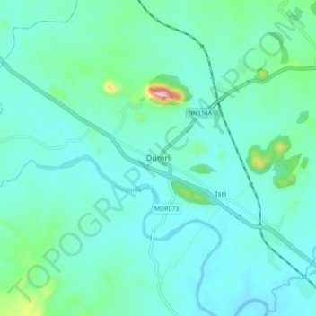
Name: Dumri topographic map, elevation, terrain.

Location: Dumri, Giridih District, Jharkhand, 825106, India (23.95432 85.97187 24.03432 86.05187)

Average elevation: 293 m

Minimum elevation: 249 m

Maximum elevation: 539 m

Gear up for your next adventure:

🧴Sunscreen SPF - Broad-spectrum sunscreen for outdoor activities
🧦Crew Hiking Socks - Comfortable socks for long-distance hikes
🧴Outdoor Sunscreen - High SPF protection for high-altitude UV exposure
🛶Canoe Life Vest - Safety vest for water sports
👖Convertible Hiking Pants - Zip-off legs to adapt to changing weather conditions

As an Amazon Associate, this site earns from qualifying purchases at no extra cost to you.