
Salas topographic map
Interactive map
Click on the map to display elevation.
About this map
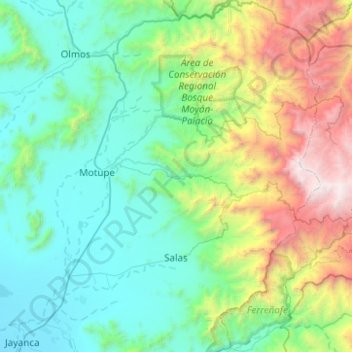
Name: Salas topographic map, elevation, terrain.
Location: Salas, Lambayeque, Peru (-6.40646 -79.70806 -5.91277 -79.40181)
Average elevation: 949 m
Minimum elevation: 57 m
Maximum elevation: 4,025 m
Other topographic maps
Click on a map to view its topography, its elevation and its terrain.
Chongoyape
Peru > Lambayeque > Chongoyape
Chongoyape, Chiclayo, Lambayeque, Peru
Average elevation: 574 m