Geolocate

Cibodas topographic map

Click on the map to display elevation.

About this map

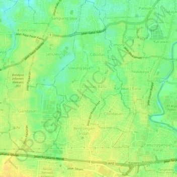
Name: Cibodas topographic map, elevation, terrain.

Location: Cibodas, Tangerang, Banten, Java, Indonesia (-6.22786 106.58538 -6.17923 106.63077)

Average elevation: 21 m

Minimum elevation: 7 m

Maximum elevation: 30 m

Other topographic maps

Click on a map to view its topography, its elevation and its terrain.

East Asia

Indonesia > Banten > Tangerang

Average elevation: 12 m

East Asia

Indonesia > Banten > Tangerang

Average elevation: 12 m

West Europe

Indonesia > Banten > Tangerang

Average elevation: 9 m

Gear up for your next adventure:

🧢Sun Protection Cap - Breathable cap to protect from sun exposure
🧭GPS Handheld Device - Reliable GPS navigation for outdoor adventures
🧰Survival Kit - Essential gear for emergencies in the wilderness
🥾Trail Hiking Socks - Comfortable socks to prevent blisters and fatigue
🧳Compression Sacks - Maximize space in your backpack by shrinking gear

As an Amazon Associate, this site earns from qualifying purchases at no extra cost to you.