Geolocate

Cotes topographic map

Click on the map to display elevation.

About this map

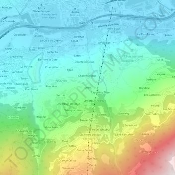
Name: Cotes topographic map, elevation, terrain.

Location: Cotes, Gressan, Aosta Valley, 11100, Italy (45.69364 7.29111 45.73364 7.33111)

Average elevation: 981 m

Minimum elevation: 553 m

Maximum elevation: 2,166 m

Gear up for your next adventure:

🧣Evaporative Cooling Towel - Beat the heat during intense summer climbs
👟Leg Gaiters - Keep debris, mud, and snow out of your boots
🧭Orienteering Kit - Tools for map reading and navigation in the wild
🎒Backpack Rain Cover - External shield to keep your entire pack dry
🌬️Windproof Camp Stove - Efficient cooking even on exposed mountain peaks

As an Amazon Associate, this site earns from qualifying purchases at no extra cost to you.