
Make a donation
Gear up for your next adventure:
As an Amazon Associate, this site earns from qualifying purchases at no extra cost to you.
Monte Paletto topographic map
Click on the map to display elevation.
Make a donation
Gear up for your next adventure:
As an Amazon Associate, this site earns from qualifying purchases at no extra cost to you.
About this map
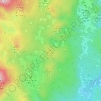
Name: Monte Paletto topographic map, elevation, terrain.
Location: Monte Paletto, Asiago, Vicenza, Veneto, Italia (45.97712 11.51971 45.97722 11.51981)
Average elevation: 1,776 m
Minimum elevation: 1,622 m
Maximum elevation: 2,029 m
Make a donation
Gear up for your next adventure:
As an Amazon Associate, this site earns from qualifying purchases at no extra cost to you.
Other topographic maps
Click on a map to view its topography, its elevation and its terrain.
Osservatorio Astrofisico di Asiago
Italia > Veneto > Vicenza > Asiago > Clama
L'osservatorio è ubicato sull'altopiano di Asiago in località Pennar, ad un'altitudine di circa 1050 m s.l.m. A 3,85 km in linea d'aria a sud-est dell'osservatorio si trova la stazione osservativa di Asiago Cima Ekar, di cui ospita i terminali di controllo.
Average elevation: 1,039 m