Geolocate

Ibajay topographic map

Click on the map to display elevation.

About this map

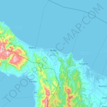
Name: Ibajay topographic map, elevation, terrain.

Location: Ibajay, Aklan, Western Visayas, Philippines (11.63681 122.09551 11.98091 122.26524)

Average elevation: 68 m

Minimum elevation: -2 m

Maximum elevation: 861 m

Other topographic maps

Click on a map to view its topography, its elevation and its terrain.

Agdugayan

Philippines > Aklan > Pandan

Average elevation: 32 m

Tigayon

Philippines > Aklan > Kalibo > Linabuan Norte > Tigayon

Average elevation: 10 m

Bagong Barrio

Philippines > Aklan > Makato > Bagong Barrio

Average elevation: 312 m

Andagao

Philippines > Aklan > Kalibo

Average elevation: 7 m

Lupo

Philippines > Aklan > Altavas > Lupo

Average elevation: 76 m

Gear up for your next adventure:

🧳Compression Sacks - Maximize space in your backpack by shrinking gear
🧭GPS Handheld Device - Reliable GPS navigation for outdoor adventures
🛏️Camping Sleeping Mat - Comfortable mats for sleeping outdoors
🚑Survival Whistle - Signal for help across long distances in mountains
🐕Hiking Dog Pack - Let your canine companion carry their own water and food

As an Amazon Associate, this site earns from qualifying purchases at no extra cost to you.