
Semanu topographic map
Click on the map to display elevation.
About this map
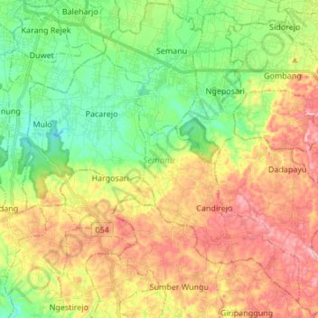
Name: Semanu topographic map, elevation, terrain.
Average elevation: 229 m
Minimum elevation: 118 m
Maximum elevation: 382 m
Other topographic maps
Click on a map to view its topography, its elevation and its terrain.
Pantai Timang
Indonesia > Special Region of Yogyakarta > Gunungkidul Regency > Tepus > Purwodadi
Average elevation: 40 m
Sepanjang Beach
Indonesia > Special Region of Yogyakarta > Gunungkidul Regency > Kemadang
Average elevation: 15 m