
Make a donation
Gear up for your next adventure:
As an Amazon Associate, this site earns from qualifying purchases at no extra cost to you.
Meyerton topographic map
Click on the map to display elevation.
Make a donation
Gear up for your next adventure:
As an Amazon Associate, this site earns from qualifying purchases at no extra cost to you.
About this map
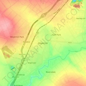
Name: Meyerton topographic map, elevation, terrain.
Average elevation: 1,479 m
Minimum elevation: 1,421 m
Maximum elevation: 1,526 m
Make a donation
Gear up for your next adventure:
As an Amazon Associate, this site earns from qualifying purchases at no extra cost to you.
Other topographic maps
Click on a map to view its topography, its elevation and its terrain.
Modderfontein
South Africa > Gauteng > Sedibeng District Municipality > Midvaal Local Municipality
Average elevation: 1,534 m
Bass Lake
South Africa > Gauteng > Sedibeng District Municipality > Midvaal Local Municipality
Average elevation: 1,473 m
Modderfontein
South Africa > Gauteng > Sedibeng District Municipality > Midvaal Local Municipality
Average elevation: 1,534 m