Geolocate

Saratoga topographic map

Click on the map to display elevation.

About this map

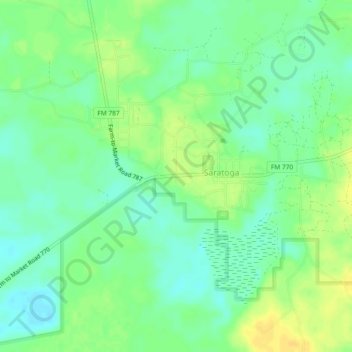
Name: Saratoga topographic map, elevation, terrain.

Location: Saratoga, Hardin County, Texas, 77585, United States (30.26455 -94.54339 30.30455 -94.50339)

Average elevation: 25 m

Minimum elevation: 13 m

Maximum elevation: 37 m

Other topographic maps

Click on a map to view its topography, its elevation and its terrain.

Lumberton

United States > Texas > Hardin County

Average elevation: 13 m

Silsbee

United States > Texas > Hardin County

Average elevation: 20 m

Kountze

United States > Texas > Hardin County

Average elevation: 22 m

Sour Lake

United States > Texas > Hardin County

Average elevation: 13 m

Rose Hill Acres

United States > Texas > Hardin County

Average elevation: 7 m

Lumberton

United States > Texas > Hardin County

Average elevation: 13 m

Kountze

United States > Texas > Hardin County

Average elevation: 22 m

Sour Lake

United States > Texas > Hardin County

Average elevation: 13 m

Gear up for your next adventure:

🥾Hiking Boots - Sturdy boots providing ankle support and traction on rugged trails
🥾Hiking Leggings - Comfortable leggings for outdoor activities
🕯️Camping Lantern - Illuminates your entire campsite with high-efficiency LEDs
🧭Orienteering Kit - Tools for map reading and navigation in the wild
🧊Insulated Water Bottle - Keeps drinks cold in summer and prevents freezing in winter

As an Amazon Associate, this site earns from qualifying purchases at no extra cost to you.