
Make a donation
Gear up for your next adventure:
As an Amazon Associate, this site earns from qualifying purchases at no extra cost to you.
Clarksville topographic map
Click on the map to display elevation.
Make a donation
Gear up for your next adventure:
As an Amazon Associate, this site earns from qualifying purchases at no extra cost to you.
Clarksville
Spadra was the first county seat of Johnson County, convenient to steamboat lines. However, when stagecoach and train transportation became more common, land routes from Little Rock to Fort Smith were directed along higher elevations through Clarksville. As Clarksville grew, it became the de facto location for the county seat circa 1833, probably due to severe flooding at Spadra. Clarksville was established by survey in November 1836 after Johnson County was formed from part of Pope County. The first court session was held in 1837 in a private building.
Make a donation
Gear up for your next adventure:
As an Amazon Associate, this site earns from qualifying purchases at no extra cost to you.
About this map
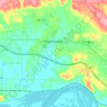
Name: Clarksville topographic map, elevation, terrain.
Location: Clarksville, Johnson County, Arkansas, 72830, United States (35.42239 -93.53741 35.49780 -93.41600)
Average elevation: 137 m
Minimum elevation: 102 m
Maximum elevation: 238 m
Make a donation
Gear up for your next adventure:
As an Amazon Associate, this site earns from qualifying purchases at no extra cost to you.
Other topographic maps
Click on a map to view its topography, its elevation and its terrain.