
Make a donation
Gear up for your next adventure:
As an Amazon Associate, this site earns from qualifying purchases at no extra cost to you.
Kikonge topographic map
Click on the map to display elevation.
Make a donation
Gear up for your next adventure:
As an Amazon Associate, this site earns from qualifying purchases at no extra cost to you.
About this map
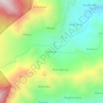
Name: Kikonge topographic map, elevation, terrain.
Location: Kikonge, Kasese, Western Region, Uganda (0.40367 30.07650 0.44367 30.11650)
Average elevation: 1,920 m
Minimum elevation: 1,534 m
Maximum elevation: 2,530 m
Make a donation
Gear up for your next adventure:
As an Amazon Associate, this site earns from qualifying purchases at no extra cost to you.
Other topographic maps
Click on a map to view its topography, its elevation and its terrain.
Rwenzori Mountains
There is no water shortage in the Ruwenzori; yet, several members of the afro-alpine family resemble species that normally thrive in desert climates. The reason lies in their similar water economy. Water is not always readily available to the afroalpine plants when they need it. In addition, nightly frosts…
Average elevation: 1,570 m