
Make a donation
Gear up for your next adventure:
As an Amazon Associate, this site earns from qualifying purchases at no extra cost to you.
Gambier Island topographic map
Click on the map to display elevation.
Make a donation
Gear up for your next adventure:
As an Amazon Associate, this site earns from qualifying purchases at no extra cost to you.
About this map
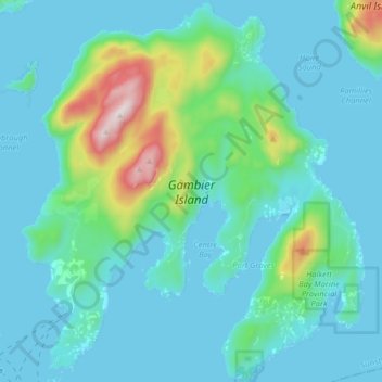
Name: Gambier Island topographic map, elevation, terrain.
Average elevation: 130 m
Minimum elevation: -1 m
Maximum elevation: 897 m
Sunshine Coast Regional District trails, hiking, mountain biking, running and outdoor activities
Make a donation
Gear up for your next adventure:
As an Amazon Associate, this site earns from qualifying purchases at no extra cost to you.
Other topographic maps
Click on a map to view its topography, its elevation and its terrain.
Langdale
Canada > British Columbia > Sunshine Coast Regional District > Area F (West Howe Sound)
Average elevation: 55 m
Highest Peak
Canada > British Columbia > Sunshine Coast Regional District > Area F (West Howe Sound) > Plumper Cove
Average elevation: 42 m
Langdale
Canada > British Columbia > Sunshine Coast Regional District > Area F (West Howe Sound)
Average elevation: 55 m