Geolocate

Alakode topographic map

Interactive map

Click on the map to display elevation.

About this map

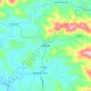
Name: Alakode topographic map, elevation, terrain.

Location: Alakode, Taliparamba, Kannur district, Kerala, 670571, India (12.15156 75.42714 12.23156 75.50714)

Average elevation: 167 m

Minimum elevation: 13 m

Maximum elevation: 679 m

Other topographic maps

Click on a map to view its topography, its elevation and its terrain.

Vellikkeel

India > Kerala > Taliparamba > Kulakkatuvayal

Vellikkeel, Kulakkatuvayal, Taliparamba, Kannur district, Kerala, India

Average elevation: 26 m

Taliparamba

India > Kerala > Taliparamba

Taliparamba, Kannur district, Kerala, 670141, India

Average elevation: 36 m

Pariyaram

India > Kerala > Taliparamba > Pariyaram

Pariyaram, Taliparamba, Kannur district, Kerala, 670502, India

Average elevation: 27 m