
Make a donation
Gear up for your next adventure:
As an Amazon Associate, this site earns from qualifying purchases at no extra cost to you.
Evrychou topographic map
Click on the map to display elevation.
Make a donation
Gear up for your next adventure:
As an Amazon Associate, this site earns from qualifying purchases at no extra cost to you.
Evrychou
Evrychou is located in Nicosia District and it is the agricultural centre of the "Solea" region. It is located about 50 km south-west of Nicosia and 30 km from mount Troodos. The village is built at the east bank of the Karkotis (or Klarios) River, at an average altitude of 440 metres. The climate of the region is typically Mediterranean and so the cultivations found around the village vary from fruit-bearing trees (mainly apple, pear, plum, apricot, and peach trees) to citrus-trees, almond and olive trees. There are also cultivations of vines, vegetables and cereals.
Make a donation
Gear up for your next adventure:
As an Amazon Associate, this site earns from qualifying purchases at no extra cost to you.
About this map
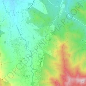
Name: Evrychou topographic map, elevation, terrain.
Location: Evrychou, Nicosia District, Cyprus (35.02120 32.88218 35.06120 32.92218)
Average elevation: 478 m
Minimum elevation: 300 m
Maximum elevation: 848 m
Make a donation
Gear up for your next adventure:
As an Amazon Associate, this site earns from qualifying purchases at no extra cost to you.