
Peliatan topographic map
Interactive map
Click on the map to display elevation.
About this map
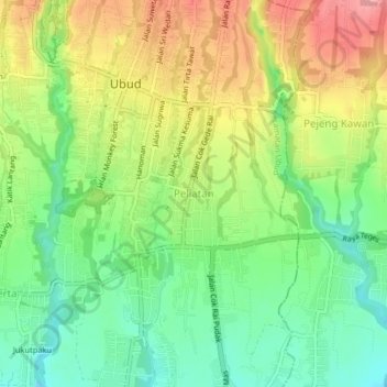
Name: Peliatan topographic map, elevation, terrain.
Average elevation: 187 m
Minimum elevation: 129 m
Maximum elevation: 260 m
Other topographic maps
Click on a map to view its topography, its elevation and its terrain.
Taman Desa Sayan
Indonésie > Bali > Gianyar > Ubud
Taman Desa Sayan, Jl. Raya Tebongkang, Sayan, Kecamatan Ubud, Kabupaten Gianyar, Bali 80571, Ubud, Gianyar, Bali, Nusa Tenggara, 80571, Indonésie
Average elevation: 179 m