
Make a donation
Gear up for your next adventure:
As an Amazon Associate, this site earns from qualifying purchases at no extra cost to you.
Sligo topographic map
Click on the map to display elevation.
Make a donation
Gear up for your next adventure:
As an Amazon Associate, this site earns from qualifying purchases at no extra cost to you.
About this map
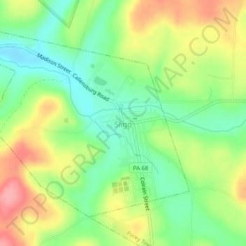
Name: Sligo topographic map, elevation, terrain.
Location: Sligo, Clarion County, Pennsylvania, United States (41.09795 -79.51164 41.11854 -79.48146)
Average elevation: 376 m
Minimum elevation: 330 m
Maximum elevation: 436 m
Make a donation
Gear up for your next adventure:
As an Amazon Associate, this site earns from qualifying purchases at no extra cost to you.
Other topographic maps
Click on a map to view its topography, its elevation and its terrain.
Helen Furnace
United States > Pennsylvania > Clarion County > Highland Township
Average elevation: 441 m
Frills Corners
United States > Pennsylvania > Clarion County > Washington Township
Average elevation: 482 m
Make a donation
Gear up for your next adventure:
As an Amazon Associate, this site earns from qualifying purchases at no extra cost to you.
Make a donation
Gear up for your next adventure:
As an Amazon Associate, this site earns from qualifying purchases at no extra cost to you.