Geolocate

Bosconia topographic map

Click on the map to display elevation.

About this map

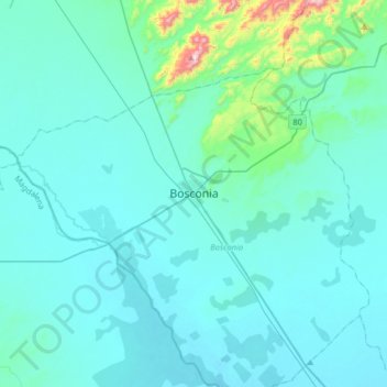
Name: Bosconia topographic map, elevation, terrain.

Location: Bosconia, Cesar, RAP Caribe, 201020, Colombia (9.81304 -74.04610 10.13304 -73.72610)

Average elevation: 109 m

Minimum elevation: 47 m

Maximum elevation: 741 m

Other topographic maps

Click on a map to view its topography, its elevation and its terrain.

Río Ariguaní

Colombia > Cesar > Bosconia

Average elevation: 68 m

Gear up for your next adventure:

🧥Insulated Jacket - Keep warm in cold outdoor conditions
🧦Merino Wool Socks - Moisture-wicking comfort for long-distance hiking
🥾Approach Shoes - Shoes designed for climbing approaches and rugged trails
Backpacking Tent - Lightweight tent for long-distance hiking trips
🧭GPS Tracker - Track your location in remote areas safely

As an Amazon Associate, this site earns from qualifying purchases at no extra cost to you.