Geolocate

Tarlton topographic map

Click on the map to display elevation.

Tarlton

Tarlton's elevation is 902 feet above sea level.

Wikipedia (CC-BY-SA 3.0)

About this map

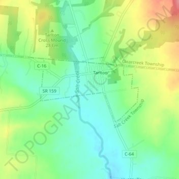
Name: Tarlton topographic map, elevation, terrain.

Location: Tarlton, Pickaway County, Ohio, 43156, United States (39.54847 -82.78769 39.55824 -82.76857)

Average elevation: 287 m

Minimum elevation: 253 m

Maximum elevation: 342 m

Other topographic maps

Click on a map to view its topography, its elevation and its terrain.

Little Chicago

United States > Ohio > Pickaway County > Ashville

Average elevation: 215 m

Derby

United States > Ohio > Pickaway County

Average elevation: 278 m

Marcy

United States > Ohio > Pickaway County

Average elevation: 286 m

Hargus Lake

United States > Ohio > Pickaway County

Average elevation: 260 m

Whisler

United States > Ohio > Pickaway County

Average elevation: 249 m

Gear up for your next adventure:

Backpacking Tent - Lightweight tent for long-distance hiking trips
🦌Outdoor Trail Camera - Monitor wildlife activity near your favorite spots
Camping Groundsheet - Protect your tent from moisture and dirt
🧥Waterproof Pants - Keep dry during rainy hiking conditions
Lightweight Backpacking Tent - Compact tent for efficient hiking trips

As an Amazon Associate, this site earns from qualifying purchases at no extra cost to you.