
Thank you for supporting this site ❤️
Make a donation
Make a donation
Gear up for your next adventure:
As an Amazon Associate, this site earns from qualifying purchases at no extra cost to you.
Thenzawl topographic map
Click on the map to display elevation.
Thank you for supporting this site ❤️
Make a donation
Make a donation
Gear up for your next adventure:
As an Amazon Associate, this site earns from qualifying purchases at no extra cost to you.
About this map
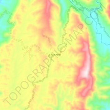
Name: Thenzawl topographic map, elevation, terrain.
Location: Thenzawl, Serchhip, Serchhip District, Mizoram, 796186, India (23.24128 92.73534 23.32128 92.81534)
Average elevation: 738 m
Minimum elevation: 408 m
Maximum elevation: 1,101 m
Thank you for supporting this site ❤️
Make a donation
Make a donation
Gear up for your next adventure:
As an Amazon Associate, this site earns from qualifying purchases at no extra cost to you.