Geolocate

Correll topographic map

Click on the map to display elevation.

About this map

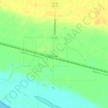
Name: Correll topographic map, elevation, terrain.

Location: Correll, Big Stone County, Minnesota, United States (45.22714 -96.17029 45.23557 -96.15488)

Average elevation: 299 m

Minimum elevation: 285 m

Maximum elevation: 314 m

Gear up for your next adventure:

🧼Travel Hand Sanitizer - Keep hands clean when water is scarce
🩹Compact First Aid Kit - Pre-packed essentials for common trail injuries
🧦Hiking Socks - Moisture-wicking and comfortable socks for long hikes
💡LED Camping Lantern - Illuminate your campsite with long-lasting lanterns
🧥Packable Rain Jacket - Breathable waterproof layer for unpredictable weather

As an Amazon Associate, this site earns from qualifying purchases at no extra cost to you.