Geolocate

Schönbachkopf topographic map

Click on the map to display elevation.

About this map

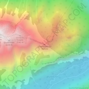
Name: Schönbachkopf topographic map, elevation, terrain.

Location: Schönbachkopf, Kuchl, Bezirk Hallein, Salzburg, 5431, Austria (47.58391 13.12067 47.58401 13.12077)

Average elevation: 1,261 m

Minimum elevation: 480 m

Maximum elevation: 2,275 m

Gear up for your next adventure:

🚲MTB Frame Bag - Carry tools and maps directly on your bicycle frame
🌡️Emergency Mylar Blankets - Compact thermal protection for unexpected nights outdoors
🧼Travel Hand Sanitizer - Keep hands clean when water is scarce
💧Filtered Water Bottle - Safe drinking water on the go
👖Convertible Hiking Pants - Zip-off legs to adapt to changing weather conditions

As an Amazon Associate, this site earns from qualifying purchases at no extra cost to you.