
Make a donation
Gear up for your next adventure:
As an Amazon Associate, this site earns from qualifying purchases at no extra cost to you.
Comigne topographic map
Click on the map to display elevation.
Make a donation
Gear up for your next adventure:
As an Amazon Associate, this site earns from qualifying purchases at no extra cost to you.
About this map
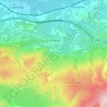
Name: Comigne topographic map, elevation, terrain.
Average elevation: 212 m
Minimum elevation: 65 m
Maximum elevation: 531 m
Make a donation
Gear up for your next adventure:
As an Amazon Associate, this site earns from qualifying purchases at no extra cost to you.
Other topographic maps
Click on a map to view its topography, its elevation and its terrain.
Pech de Bugarach
France > Occitanie > Aude > Bugarach
C'est le point culminant du massif des Corbières avec 1 230 mètres d'altitude. De son sommet, le panorama s'étend des Pyrénées à la montagne Noire et de la Méditerranée à la haute vallée de l'Aude.
Average elevation: 768 m
Make a donation
Gear up for your next adventure:
As an Amazon Associate, this site earns from qualifying purchases at no extra cost to you.